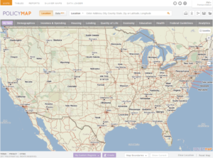
PolicyMap is a web-based, online mapping and reporting tool that offers data on U.S. demographics, real estate, health, jobs, education, and more. The program allows users to make maps, tables, and reports from an extensive collection of datasets.
While some features of PolicyMap are available for free, the Library’s paid subscription and site license mean you have access to more data, including proprietary data, as well as powerful mapping, reporting, and analytical tools.
 When you access PolicyMap through the Library website, you can use PolicyMap to do the following:
- Make maps
- Upload your own address-level data
- Download data
- Create market reports
- Find areas that meet up to three criteria
- Share your data and interactive maps with others
PolicyMap includes datasets from approximately one hundred public and proprietary sources. Some of the proprietary data sources (not available in the free version) including the following:
- Home sales data
- Locations of non-profit organizations
- School district ratings and performance
The PolicyMap Data Directory details their complete list of public and proprietary data sources.
PolicyMap offers several tutorials and guides to help users learn and finesse the tools and features. For even more detail, the PolicyMap Primer provides a complete overview of all the PolicyMap features and functions.
If you have questions about PolicyMap, please ask a librarian.

